Instruments
Note
If you are looking for more detailed info about the lab’s instruments (manuals, tutorials, pictures, ecc), please visit the Moodle page. Access restricted to lab’s students and staff.
Electrical Methods
VES
Instruments to perform Vertical Electric Sounding (VES). These instruments allow to reconstruct the vertical variation of electrical resistivity in areas where the subsoil heterogeneity can be approximated as an horizontal layering.
- PASI 16GL
With this instrument and the available tools, a maximum opening of the current dipole of 1000 m can be set up. The instrument can be also used to perform stationary field measurements on the cells of water-saturated unconsolidated sediments described at the section SIP and DC.
ERGI
Instruments to perform Electrical Resistivity Ground Imaging (ERGI) surveys.
- PASI Polares
With the available tools, allows to use up to 3x16 electrodes, with a maximum spacing of 5 m. It works with an alternating current signal, allowing fast measurements and the simultaneous acquisition of data related to resistivity and induced polarization.
SIP and DC
We set up a system of cells for Spectral Induced Polarization (SIP) and Direct Current (DC) measurements of electrical conductivity of reconstructed samples of water-saturated unconsolidated sediments.
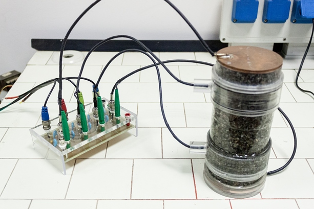
Spectral Induced Polarization cells.
This system of data acquisition uses cells that contain alluvial unconsolidated sediments and are equipped with four electrodes: two copper discs at the extremes to generate an electrical field and current flow through the sample; two metallic grids (copper for measurements with stationary fields; Ag-AgCl for measurements with alternate fields) located at intermediate positions of the cells, to measure potential differences. The cells and the amplification system, which is based on that proposed by Zimmermann et al.(2008), have been realized in the lab for Geophysics for the Environment and Cultural Heritage. For measurements with stationary fields the georesistivimeter PASI 16GL can be used, whereas the measurements with alternate fields are performed with the waveform generator Agilent 33500B and the 12-bit digital acquisition system PicoScope 4424. These cells permits the execution of SIP measurements (dependence of complex electrical resistivity on frequency in the interval from 1 mHz to 10 kHz).
Related Pubblications:
S.Inzoli, M.Giudici, J.A.Huisman “Estimation of sediment texture from spectral induced polarisation data using cluster and principal component analysis”, DOI: 10.3997/1873-0604.2016033, URI: http://hdl.handle.net/2434/502625
S.Inzoli, M.Giudici “A comparison between single- and multi-objective optimization to fit spectral induced polarization data from laboratory measurements on alluvial sediments”, DOI: 10.1016/j.jappgeo.2015.09.017, URI: http://hdl.handle.net/2434/346101
S.Inzoli, M.Giudici “A comparison between single- and multi-objective optimization to fit spectral induced polarization data from laboratory measurements on alluvial sediments”, DOI: 10.1016/j.jappgeo.2015.09.017, URI: http://hdl.handle.net/2434/346101
References:
Zimmermann et al.(2008), DOI: 10.1088/0957-0233/19/10/105603.
Seismology/Vibrations
HVSR
Instruments to perform Horizontal-to-Vertical Spectral Ratio (HVSR): these instruments collect HVSR data and allow to reconstruct the subsoil layering in terms of s-wave propagation-velocity after inversion with dedicated software tools.
- PASI Gemini 2
3D Geophone for HVSR measurements, used to collect HVSR (Horizontal-to-Vertical Spectral Ratio) data, to reconstruct the subsoil layering in terms of s-wave propagation-velocity after inversion with dedicated software tools.
Soil Moisture
- Trase, mod. 6050X1
Portable Time Domain Reflectometry (TDM) system.
- IMKO, mod. TRIME-FM
Mobile moisture meter.
Water properties
- WTW, Cond 330i/SET
Portable instrument to measure electrical conductivity of water samples.
Geomagnetic methods
- GEM Systems, mod. GSM-19T
Proton Magnetometer (gradiometer) equipped with two sensors of the Earth’s magnetic field, which permit the execution of magnetic and gradiometric measurements. The instrument is mostly used for teaching demonstrations and allows to reveal the presence of metallic bodies in the subsoil.
- EG&G Geometrics, mod. G~856
Proton Magnetometer, equipped with one sensors of the Earth’s magnetic field, permit the execution of magnetic measurements. The instrument is mostly used for teaching demonstrations.
Electromagnetic methods
- Geophex, mod. Gem-2 Ski
Handheld, digital, programmable, broadband electromagnetic sensor. Can aquire up to five frequency signals simultaneously, from 300 Hz to 96 kHz.
- GSSI, mod. SIR-4000
Ground Penetrating Radar (GPR). The digical control unit (SIR-4000) is equipped with a dual frequency antenna 300 MHz/800 MHz. For the survey, we dispose of one with three-wheel survey chart (rough terrain) and one four-wheel survey chart.
Microclimatology
- Kestrel, mod. 5500
Portable Weather Meter measuring: wind speed, temperature, wind chill, relative humidity, heat stress index, dew-point temp., wet bulb temp., pressure, wind direction, crosswind.
- Delta OHM, mod. HD 2302.0
Light meter, equipped with a wide range (LP 471 RAD) and a UVA (LP 471 UVA) probes.
- Flir, C3
Compact Thermal Imaging system, spectral range 7.5 μm - 14.0 μm.
- Trotec, mod. T3000
Multifunction measuring meter equipped with sensors for measurements of the following quantities: air temperature and RH (TS210 SDI); air velocity (TS470 SDI); material moisture (resistive, TS0606; capacitive, TS660 SDI; microwave, TS610 SDI); surface temperature (TS131/150 SDI).
Hydro-meteorological station
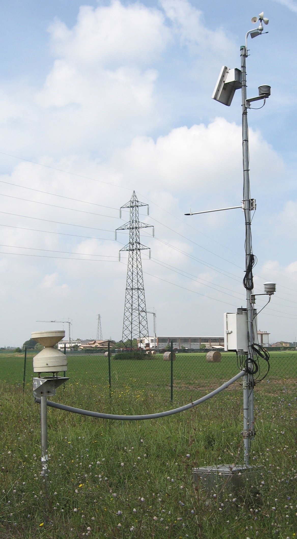
Roncopascolo hydro-meteo station¶ |
Our Lab. manages a hydro-meteorologic measurement station located in the Taro River plain, in Roncopascolo (PR), Italy. The station records, every 20’, measurements of: relative humidity at 2 m and 4 m, air temperature at 2 m and 4 m, net radiative flux, heat flux, wind speed and direction, rainfall. In addition, 8 EnviroSMART probes are used to measure soil moisture up to 2 m below the ground level. Related publications:
|
Software
Besides developing its own tools (see Codes), the Lab disposes of Licenses of the main commercial packages dedicated to the processing and interpretation of geophysical data including RADAN, Res2Dinv and Res3Dinv, winMASW, WinSism and VisualSUNT.